 |
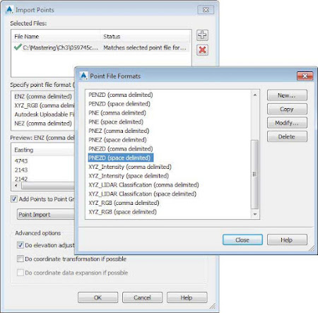
| Figure 1: The Import Points and Point File Formats dialogs. |
 To add a file to your Import Points dialog, click the white plus sign to browse. You can add multiple files at once if they are in the same point format—such as a comma-delimited point number, northing, easting, elevation, description (i.e., PNEZD). The import process supports most text formats as well as Microsoft Access database (MDB) files.
When your file is listed in the top of the dialog, a green check mark indicates that Civil 3D can parse the information. Be careful, though, because Civil 3D does not know the difference between a northing and an easting or a point number and an elevation. You still need to select the correct file format. When the format of the imported data does not match any of the present formats, a red mark will be displayed, and you will not be able to proceed without defining a custom import format that matches the layout of the data, as shown in Figure 1.
 The file format filter is available to help you. Civil 3D recognizes how the file is delimited (i.e., tab, comma, space) and shows you only the formats that apply. If you don’t want the help, you can turn the filtering off by clicking the Filter icon. This will give you access to the full list of formats defined in the drawing.
- Point Settings
- Importing Points from a Text File
- Converting Points from Non–Civil 3D Sources
- A Closer Look at the Create Points Toolbar
