Converting Points from Non–Civil 3D Sources

Base AutoCAD points, Land Desktop points, and Softdesk points are types of data that Civil 3D can readily convert from within a drawing. Other types of data that can be converted to Civil 3D points are represented by blocks. To convert, blocks must minimally be defined so that the insertion point’s coordinates coincides with the coordinate values of the point and have an assigned z value that defines the elevation. If a block also has the number, description, and elevation as block attributes, it is even easier to convert them to Civil 3D points. Therefore, whenever possible, your best course of action would be to request the survey in text format or LandXML that can be easily imported into Civil 3D. However, if you need to migrate a drawing that contains legacy point data, tools are available to convert that data to Civil 3D point objects.

A Land Desktop point database (the Points.mdb fi le found in the COGO folder in a Land Desktop project) can be directly imported into Civil 3D in the same interface in which you’d import a text file.

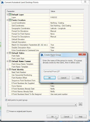
Land Desktop point objects, which appear as AECC_POINTs in the AutoCAD Properties palette, can also be converted to Civil 3D points via the Convert Land Desktop Points option (see Figure 1). Upon their conversion, this tool gives you the opportunity to assign styles, create a point group, and more.
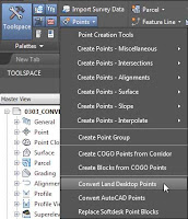
Selecting the Convert Land Desktop Points optionopens the Convert Autodesk Land Desktop Points dialog
Figure 1:  Selecting the Convert Land Desktop Points option (left) opens the Convert Autodesk Land Desktop Points dialog (right).
Next Post
Previous Post