 |  |
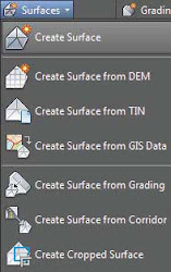
| Figure 1: Create a new surface (left). Expand a surface’s definition to add or modify elevation data (right). | |
- Boundaries
- Boundaries are closed polylines that determine data inclusion and visibility for the surface. A boundary can be a 2D polyline, a 3D polyline, or even a feature line, but only the horizontal information will be used to generate the boundary—the elevation of the polyline is ignored. If the polyline that created the boundary is modified, the surface will become out of date.
- Breaklines
- Breaklines are used to create triangulation paths, thereby preventing triangle lines that could be generated off adjacent points from crossing these paths. Breaklines are mandatory for defining flow lines, curb lines, ditch lines, pavement edges, or any linear representation of ridges or valleys. Breaklines can be defined using lines, arcs, 2D polylines, 3D polylines, survey figures, parcels, or feature lines. Similar to boundaries, if a breakline is modified, the surface will become out of date, thus requiring a rebuild. Breaklines will be discussed in more detail later in this blog.
- Contours
- Polyline representations of surfaces can be used to create a Civil 3D surface. These polylines must be assigned the elevation of the contour they represent. Points will be placed along the contours to be used in the triangulation process. In addition, algorithms are run to ensure that the Civil 3D contours generated closely match the polyline contours used to define the surface. This process will be discussed in more detail later in this blog in the section “Surfaces from Polylines”. Similar to boundaries, if the polyline contour is modified, the surface will become out of date, thus requiring a rebuild. Adding contour data will be discussed further later in this blog.
- DEM Files
- Digital Elevation Model (DEM) files are the standard format files from governmental agencies and geographic information system (GIS) systems. These files are typically large in scale but can be great for planning purposes.
- Drawing Objects
- These are AutoCAD objects that have an insertion point at an elevation (e.g., text, blocks, lines, AutoCAD points, 3D faces, or polyfaces) that can be used to populate a surface with elevation data. For text and blocks, the text insertion point z position is used as the elevation. Changes to these objects will not cause the surface to become out of date.
- Edits
- Any manipulation after the surface is completed, such as adding or removing triangles or changing the datum, will be part of the edit history. These changes can be viewed in the surface properties, where edits can be toggled on and off individually to simplify reviewing and changing. They can also be reordered since edits are applied in the order in which they are added.
- Point Files
- Point files work well when you’re working with large data sets where the points themselves don’t necessarily contain extra information. Examples include laser scanning or aerial surveys. A drawing will stay referenced to a point file. If the point file is moved or deleted, the reference in the drawing will be broken unless a surface snapshot is taken. Snapshots will be discussed later in the blog.
- Point Groups
- Civil 3D point groups or survey point groups can be created to isolate a set of points used to build a surface. The surface is linked to that point group. If points are added, removed, or modified in the point group, the surface will become out of date and must be rebuilt.
- Point Survey Queries and Figure Survey Queries
- Point survey queries and figure survey queries perform similar tasks. A saved survey query created on the Survey tab of Toolspace can be used similarly to a point group for populating surface elevation data.
===o0o===
