
The Coordinate Geometry Editor (
Figure 1) is a powerhouse tool that makes creating and evaluating 2D boundaries easier than before. The functionality introduced with this feature supplants entering parcel data one segment at a time using the Line By Bearing And Distance command. Traverse analysis can be performed on manually entered segments, polylines, or COGO point objects without needing to define them in a survey database.
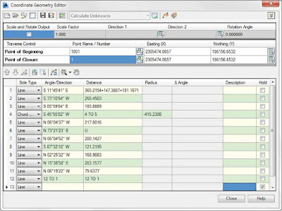 |
| Figure 1: The Coordinate Geometry Editor. |
Boundary data can be entered in the Coordinate Geometry Editor using a mix of methods. As shown in the first line of the traverse shown in
Figure 1, you can use formulas to enter data. In the example shown, multiple segments with the same bearing have been consolidated into a single entry.
If a value is unknown, such as the distance in line 6 of
Figure 1, you can enter a
U. Civil 3D will calculate the unknown value when you generate the traverse report.

To enter data using points, use the Pick COGO Points In Drawing button to select the points in the direction of the traverse side. You may need to click the chevron button in the upper-right corner of the dialog to expand the toolbar button selection. Note that the direction and distance are entered independently of each other, so you will need to repeat the selection for each column of the table. You can also copy and paste between columns.
If a line has been entered in error, the Coordinate Geometry Editor offers a variety of tools for fixing problems. To remove a line of the table, highlight the row, right-click, and select Delete Row, as shown in
Figure 2.
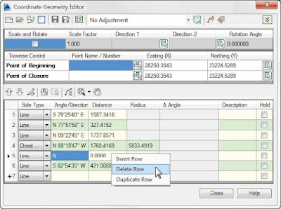 |
| Figure 2: Removing unwanted traverse data. |
Similar to the glyphs you saw in the Mapcheck command, the Coordinate Geometry glyph will appear in the graphic showing the side directions and point of closure, as shown in
Figure 3.
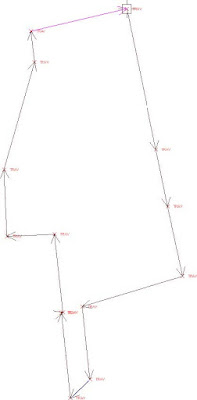 |
| Figure 3: Temporary graphics, or “glyphs,” to help you identify your boundary. |

When you want to run a traverse report, set the report type you want to run from the top of the Coordinate Geometry Editor. If you have unknowns in your traverse, your only option will be to calculate the unknown values. Click the Display Report button to view the results of your entries. Depending on the type of adjustment you chose, your results should resemble
Figure 4.
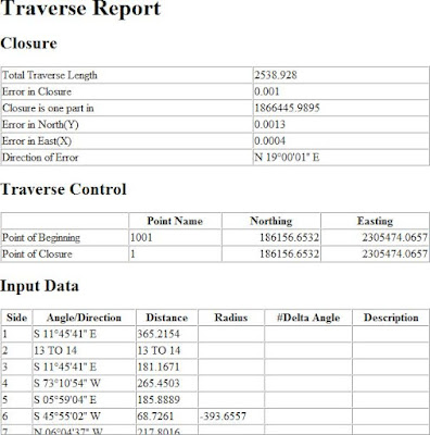 |
| Figure 4: Traverse report created by the Coordinate Geometry Editor. |

 The Coordinate Geometry Editor (Figure 1) is a powerhouse tool that makes creating and evaluating 2D boundaries easier than before. The functionality introduced with this feature supplants entering parcel data one segment at a time using the Line By Bearing And Distance command. Traverse analysis can be performed on manually entered segments, polylines, or COGO point objects without needing to define them in a survey database.
 To enter data using points, use the Pick COGO Points In Drawing button to select the points in the direction of the traverse side. You may need to click the chevron button in the upper-right corner of the dialog to expand the toolbar button selection. Note that the direction and distance are entered independently of each other, so you will need to repeat the selection for each column of the table. You can also copy and paste between columns.

 When you want to run a traverse report, set the report type you want to run from the top of the Coordinate Geometry Editor. If you have unknowns in your traverse, your only option will be to calculate the unknown values. Click the Display Report button to view the results of your entries. Depending on the type of adjustment you chose, your results should resemble Figure 4.
