As you have learned, the fundamental building blocks of surfaces are points and lines. The points are derived from some other source of data, such as standard breaklines, contours, survey points, and so on. If there is an error in one of those source objects, there will be an error in the surface as well. When this occurs, you can either edit the source data and rebuild the surface, or edit the surface itself. You have already learned about editing survey source data (survey points and survey figures), so now follow these steps to edit the surface:
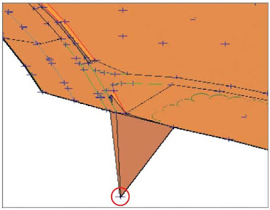
- Open the drawing named Editing Points.dwg or (Editing Points.dwg (METRIC)) located in your Exercise_04 class data folder. The two right viewports are zoomed in to the location where the driveway meets the road on the north side of the property. In this area, one of the surface points is incorrect. In the plan view on the top right, the effects of the incorrect point can be seen in the densely packed contours. In the 3D view on the bottom right, the erroneous point appears as a downward spike in the surface.
- Click one of the contours to select the surface, and then click Surface Properties on the ribbon.
- In the Surface Properties dialog box, click the Information tab and change the Surface style to Triangles And Points. Click OK. The display of the surface will change to lines and points, with the points appearing as plus-sign markers.
- Click any TIN line to select the surface, and then click Edit Surface ➢ Modify Point on the ribbon.
- When prompted to select a point, click the point in the 3D view that is located well below the other points (see Figure). Press Enter.
 |
| 3D view of incorrect surface point. |
- At the command line, type 190.76 (58.144) and press Enter. Notice how the surface is modified but the survey figure is left behind. Depending on the situation, it may be prudent to go back to the source data for the survey figure and correct that as well.
- Press Enter to exit the Modify Point command. Change the style of the surface back to C-Existing Contours (1') (C-Existing Contours (0.5m)). Notice that the closely spaced contours in the top-right viewport are no longer there.
 As you have learned, the fundamental building blocks of surfaces are points and lines. The points are derived from some other source of data, such as standard breaklines, contours, survey points, and so on. If there is an error in one of those source objects, there will be an error in the surface as well. When this occurs, you can either edit the source data and rebuild the surface, or edit the surface itself. You have already learned about editing survey source data (survey points and survey figures), so now follow these steps to edit the surface:


